
Historic Site · Cañar, Ecuador
Ingapirca
Ingapirca (Kichwa: Inka Pirka, "Inca wall") is a town in Cañar Province, Ecuador, and the name of the older Inca ruins and archeological site nearby.
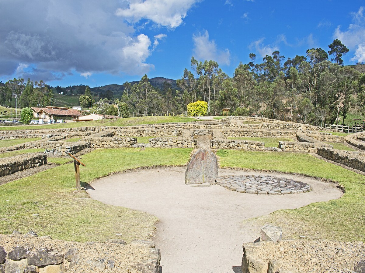
Photo: Ymblanter via Wikimedia Commons, CC BY-SA 4.0. Cropped and resized for display.
Landmark facts
| Location | Cañar, Ecuador |
|---|---|
| Type | Historic Site |
| Elevation | Elevation: 3123 m |
| Coordinates | 2.5486° S, 78.8719° W |
Every fact above is taken from the sources listed below; anything no source states is left blank rather than guessed.
What Ingapirca is known for
Ingapirca (Kichwa: Inka Pirka, "Inca wall") is a town in Cañar Province, Ecuador, and the name of the older Inca ruins and archeological site nearby.
About Ingapirca
Ingapirca (Kichwa: Inka Pirka, "Inca wall") is a town in Cañar Province, Ecuador, and the name of the older Inca ruins and archeological site nearby. These are the largest known Inca ruins in Ecuador. The most significant building is the Temple of the Sun, an elliptically shaped building constructed around a large rock.
History
This area had long been settled by the Cañari indigenous people, who called it Hatun Cañar. As the Inca Empire expanded into southern Ecuador, the Inca Túpac Yupanqui encountered the Cañari "Hatun Cañar" tribe. The Inca and Cañari decided to settle their differences and live together peacefully. The astronomical observatory was built under Inca Huayna Capac.
How to get there
| Nearest town | Cañar |
|---|---|
| Nearest airport | Mariscal Lamar Airport (CUE) |
| Distance from the airport | 24.8 miles (straight line) |
Nearest major airport by straight-line distance from the landmark’s coordinates; road distance will be longer.
Airports near this landmark
The airports a visitor would actually fly into, nearest first — each link opens its profile on our sister site AirportProfiles.
- José Joaquín de Olmedo International Airport (GYE) · Guayaquil, Ecuador · 74.9 miles away
- General Ulpiano Paez International Airport (SNC) · Salinas/La Libertad, Ecuador · 147.7 miles away
Landmarks nearby
The closest landmarks in this library, by straight-line distance.
More landmarks in Ecuador
More historic sites





Frequently asked questions
What is Ingapirca?
Ingapirca (Kichwa: Inka Pirka, "Inca wall") is a town in Cañar Province, Ecuador, and the name of the older Inca ruins and archeological site nearby.
Where is Ingapirca located?
Ingapirca is in Cañar, Ecuador. Its coordinates are 2.5486° S, 78.8719° W.
How do I get to Ingapirca?
The nearest town is Cañar, and the nearest airport is Mariscal Lamar Airport (CUE), about 24.8 miles away (straight line).
What is the history of Ingapirca?
This area had long been settled by the Cañari indigenous people, who called it Hatun Cañar. As the Inca Empire expanded into southern Ecuador, the Inca Túpac Yupanqui encountered the Cañari "Hatun Cañar" tribe.
Sources
- https://en.wikipedia.org/wiki/Ingapirca — Wikipedia article — overview, history and core facts (CC BY-SA).
- https://www.wikidata.org/wiki/Q1478056 — Wikidata — built year, architect, height/size, visitors, official website (CC0).
- https://github.com/jbrooksuk/JSON-Airports — Nearest major airport computed from landmark and airport coordinates (haversine); airport list: jbrooksuk/JSON-Airports.
Page last updated 13 November 2026.