
Historic Site · Nazca, Peru
Nazca Lines
The Nazca lines (, ) are a group of geoglyphs made in the soil of the Nazca Desert in southern Peru. Built c. 201 BC.
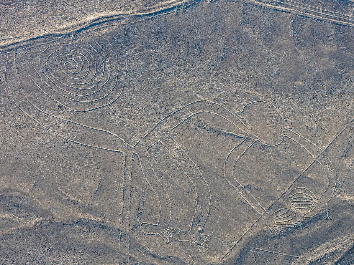
Photo: Diego Delso via Wikimedia Commons, CC BY-SA 4.0. Cropped and resized for display.
Landmark facts
| Location | Nazca, Peru |
|---|---|
| Type | Historic Site |
| Built | c. 201 BC |
| Architect | Nazca culture |
| Area | Area: 753.585 km² |
| Coordinates | 14.6975° S, 75.1350° W |
Every fact above is taken from the sources listed below; anything no source states is left blank rather than guessed.
What Nazca Lines is known for
The Nazca lines (, ) are a group of geoglyphs made in the soil of the Nazca Desert in southern Peru.
About Nazca Lines
The Nazca lines (, ) are a group of geoglyphs made in the soil of the Nazca Desert in southern Peru. They were created between 500 BC and 500 AD by people making depressions or shallow incisions in the desert floor, removing pebbles and leaving different-colored dirt exposed. There are two major phases of the Nazca lines, Paracas phase, from 400 to 200 BC, and Nazca phase, from 200 BC to 500 AD.
History
Recorded history The first published mention of the Nazca Lines was by Spanish conquistador Pedro Cieza de León in his 1553 book, where he described them as trail markers. 1 In 1569, Spanish magistrate Luis Monzón reported having seen ancient ruins in Peru, including the remains of "roads". 2 3 Although the lines were partially visible from nearby hills, the first to report them in the twentieth century were Peruvian military and civilian pilots.
How to get there
| Nearest town | Nazca |
|---|---|
| Nearest airport | Coronel FAP Alfredo Mendivil Duarte Airport (AYP) |
| Distance from the airport | 119.5 miles (straight line) |
Nearest major airport by straight-line distance from the landmark’s coordinates; road distance will be longer.
Airports near this landmark
The airports a visitor would actually fly into, nearest first — each link opens its profile on our sister site AirportProfiles.
- Maria Reiche Neuman Airport (NZC) · Nazca, Peru · 15.9 miles away
- Air Force Colonel Alfredo Mendivil Duarte Airport (AYP) · Ayacucho, Peru · 123.5 miles away
Landmarks nearby
The closest landmarks in this library, by straight-line distance.
More landmarks in Peru
More historic sites





Frequently asked questions
What is Nazca Lines?
The Nazca lines (, ) are a group of geoglyphs made in the soil of the Nazca Desert in southern Peru.
Where is Nazca Lines located?
Nazca Lines is in Nazca, Peru. Its coordinates are 14.6975° S, 75.1350° W.
How do I get to Nazca Lines?
The nearest town is Nazca, and the nearest airport is Coronel FAP Alfredo Mendivil Duarte Airport (AYP), about 119.5 miles away (straight line).
When was Nazca Lines built?
Nazca Lines was built c. 201 BC.
Sources
- https://en.wikipedia.org/wiki/Nazca_lines — Wikipedia article — overview, history and core facts (CC BY-SA).
- https://www.wikidata.org/wiki/Q2620036 — Wikidata — built year, architect, height/size, visitors, official website (CC0).
- https://github.com/jbrooksuk/JSON-Airports — Nearest major airport computed from landmark and airport coordinates (haversine); airport list: jbrooksuk/JSON-Airports.
Page last updated 13 November 2026.