
Temple · Nasiriyah, Iraq
Ziggurat of Ur
The Ziggurat of Ur is a Neo-Sumerian ziggurat in what was the city of Ur near Nasiriyah, in present-day Dhi Qar Province, Iraq. Built c. 2100 BC.
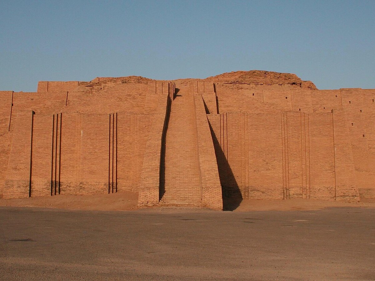
Photo: Tla2006 at English Wikipedia via Wikimedia Commons, Public domain. Cropped and resized for display.
Landmark facts
| Location | Nasiriyah, Iraq |
|---|---|
| Type | Temple |
| Built | c. 2100 BC |
| Coordinates | 30.9625° N, 46.1025° E |
Every fact above is taken from the sources listed below; anything no source states is left blank rather than guessed.
What Ziggurat of Ur is known for
The Ziggurat of Ur is a Neo-Sumerian ziggurat in what was the city of Ur near Nasiriyah, in present-day Dhi Qar Province, Iraq.
About Ziggurat of Ur
The Ziggurat of Ur is a Neo-Sumerian ziggurat in what was the city of Ur near Nasiriyah, in present-day Dhi Qar Province, Iraq. The structure was built during the Early Bronze Age by King Ur-Nammu of the Third Dynasty of Ur. It had crumbled to ruins by the 6th century BC of the Neo-Babylonian period, when it was restored by King Nabonidus.
History
The ziggurat was built by King Ur-Nammu, who dedicated it in honour of Nanna/Sîn in approximately the 21st century BC (short chronology) during the Third Dynasty of Ur. The massive step pyramid measured 64 m in length, 45 m in width and over 30 m in height. The height is speculative, as only the foundations of the Sumerian ziggurat have survived. The ziggurat was a piece in a temple complex that served as an administrative center for the city, and which was a shrine of the moon god Nanna, the patron deity of Ur.
How to get there
| Nearest town | Nasiriyah |
|---|---|
| Nearest airport | Basrah International Airport (BSR) |
| Distance from the airport | 104.1 miles (straight line) |
Nearest major airport by straight-line distance from the landmark’s coordinates; road distance will be longer.
Airports near this landmark
The airports a visitor would actually fly into, nearest first — each link opens its profile on our sister site AirportProfiles.
- Basra International Airport (BSR) · Basra, Iraq · 96.9 miles away
- Al Najaf International Airport (NJF) · Najaf, Iraq · 122.7 miles away
- Abadan Ayatollah Jami International Airport (ABD) · Abadan, Iran · 133.0 miles away
Landmarks nearby
The closest landmarks in this library, by straight-line distance.

More landmarks in Iraq
More temples



Frequently asked questions
What is Ziggurat of Ur?
The Ziggurat of Ur is a Neo-Sumerian ziggurat in what was the city of Ur near Nasiriyah, in present-day Dhi Qar Province, Iraq.
Where is Ziggurat of Ur located?
Ziggurat of Ur is in Nasiriyah, Iraq. Its coordinates are 30.9625° N, 46.1025° E.
How do I get to Ziggurat of Ur?
The nearest town is Nasiriyah, and the nearest airport is Basrah International Airport (BSR), about 104.1 miles away (straight line).
When was Ziggurat of Ur built?
Ziggurat of Ur was built c. 2100 BC.
Sources
- https://en.wikipedia.org/wiki/Ziggurat_of_Ur — Wikipedia article — overview, history and core facts (CC BY-SA).
- https://www.wikidata.org/wiki/Q202927 — Wikidata — built year, architect, height/size, visitors, official website (CC0).
- https://github.com/jbrooksuk/JSON-Airports — Nearest major airport computed from landmark and airport coordinates (haversine); airport list: jbrooksuk/JSON-Airports.
Page last updated 13 November 2026.