
Castle · Erbil, Iraq
Erbil Citadel
The Citadel of Erbil, locally called Qellat, is a tell or occupied mound, and the historical city centre of Erbil in the Kurdistan Region of Iraq.
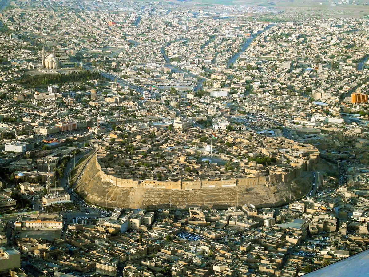
Photo: jan kurdistani via Wikimedia Commons, CC BY-SA 2.0. Cropped and resized for display.
Landmark facts
| Location | Erbil, Iraq |
|---|---|
| Type | Castle |
| Area | Area: 0.16 km² |
| Coordinates | 36.1910° N, 44.0090° E |
Every fact above is taken from the sources listed below; anything no source states is left blank rather than guessed.
What Erbil Citadel is known for
The Citadel of Erbil, locally called Qellat, is a tell or occupied mound, and the historical city centre of Erbil in the Kurdistan Region of Iraq.
About Erbil Citadel
The Citadel of Erbil, locally called Qellat, is a tell or occupied mound, and the historical city centre of Erbil in the Kurdistan Region of Iraq. The citadel was added to the World Heritage List on 21 June 2014. The earliest evidence for occupation of the citadel mound dates to the 5th millennium BC, and possibly earlier. It appears for the first time in historical sources in the Ebla tablets in modern Syria around 2000 BC, and gained particular importance during the Neo-Assyrian period.
History
The site of the citadel may have been occupied as early as the Neolithic period, as pottery fragments possibly dating to that period have been found on the slopes of the mound. Clear evidence for occupation comes from the Chalcolithic period, with sherds resembling pottery of the Ubaid and Uruk periods in the Jazira and southeastern Turkey, respectively. Given this evidence for early occupation, the citadel has been called the oldest continuously occupied town in the world. Erbil appears for the first time in literary sources around 2300 BC in the archives of Ebla.
Planning a visit? Visit the official Erbil Citadel website — the official site has the current visiting information.
How to get there
| Nearest town | Erbil |
|---|---|
| Nearest airport | Erbil International Airport (EBL) |
| Distance from the airport | 4.1 miles (straight line) |
Nearest major airport by straight-line distance from the landmark’s coordinates; road distance will be longer.
Airports near this landmark
The airports a visitor would actually fly into, nearest first — each link opens its profile on our sister site AirportProfiles.
- Erbil International Airport (EBL) · Arbil, Iraq · 4.7 miles away
- Kirkuk International Airport (KIK) · Kirkuk, Iraq · 53.4 miles away
Landmarks nearby
The closest landmarks in this library, by straight-line distance.
More landmarks in Iraq
More castles

Frequently asked questions
What is Erbil Citadel?
The Citadel of Erbil, locally called Qellat, is a tell or occupied mound, and the historical city centre of Erbil in the Kurdistan Region of Iraq.
Where is Erbil Citadel located?
Erbil Citadel is in Erbil, Iraq. Its coordinates are 36.1910° N, 44.0090° E.
How do I get to Erbil Citadel?
The nearest town is Erbil, and the nearest airport is Erbil International Airport (EBL), about 4.1 miles away (straight line).
What is the history of Erbil Citadel?
The site of the citadel may have been occupied as early as the Neolithic period, as pottery fragments possibly dating to that period have been found on the slopes of the mound. Clear evidence for occupation comes from the Chalcolithic period, with sherds resembling pottery of the Ubaid and Uruk periods in the Jazira and southeastern Turkey, respectively.
Sources
- https://en.wikipedia.org/wiki/Citadel_of_Erbil — Wikipedia article — overview, history and core facts (CC BY-SA).
- https://www.wikidata.org/wiki/Q206236 — Wikidata — built year, architect, height/size, visitors, official website (CC0).
- http://www.erbilcitadel.org/ — Official website of the landmark / managing body.
- https://github.com/jbrooksuk/JSON-Airports — Nearest major airport computed from landmark and airport coordinates (haversine); airport list: jbrooksuk/JSON-Airports.
Page last updated 13 November 2026.