
Historic Site · Cape Town, South Africa
Robben Island
Robben Island (Dutch: Robbeneiland) is an island in Table Bay, 6.
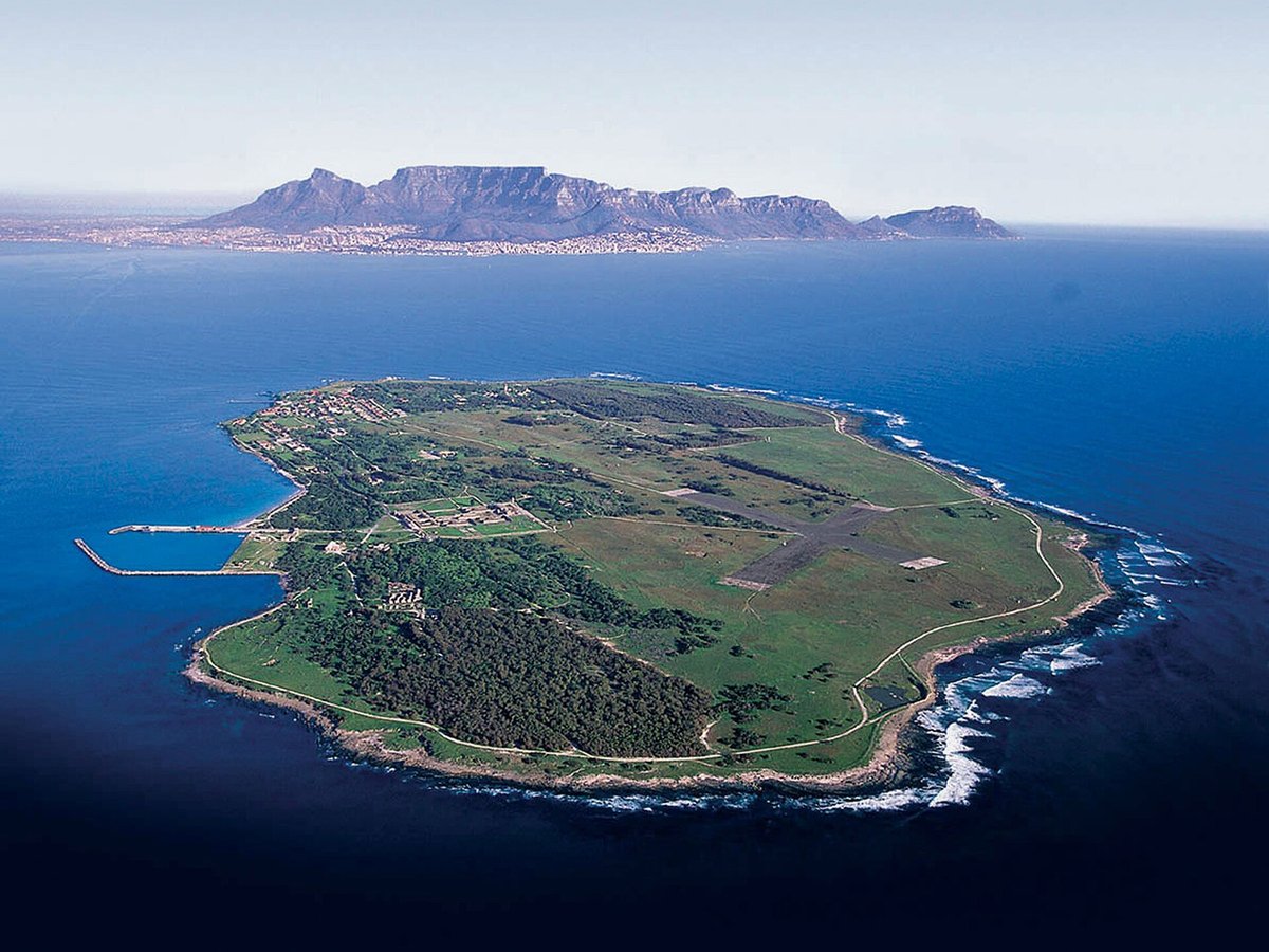
Photo: South African Tourism from South Africa via Wikimedia Commons, CC BY 2.0. Cropped and resized for display.
Landmark facts
| Location | Cape Town, South Africa |
|---|---|
| Type | Historic Site |
| Length | Length: 3.2 km |
| Coordinates | 33.8050° S, 18.3700° E |
Every fact above is taken from the sources listed below; anything no source states is left blank rather than guessed.
What Robben Island is known for
Robben Island (Dutch: Robbeneiland) is an island in Table Bay, 6.
About Robben Island
Robben Island (Dutch: Robbeneiland) is an island in Table Bay, 6.9 kilometers (4.3 mi) west of the coast of Bloubergstrand, north of Cape Town, South Africa. It takes its name from the archaic Dutch word for seals (robben). The island is roughly oval in shape, 3.3km long north–south, and 1.9km wide, with an area of 5.08 sq.
History
Located at the entrance to Table Bay, 11 km from Cape Town, the island was discovered by Bartolomeu Dias in 1488. It was used by the Portuguese navigators, and later by English and Dutch sailors, as a refueling station. In 1654, the settlers of the Dutch Cape Colony sheltered their livestock on the island, since the lack of predators offered better protection than on the mainland.
Planning a visit? Visit the official Robben Island website — the official site has the current visiting information.
How to get there
| Nearest town | Cape Town |
|---|---|
| Nearest airport | Cape Town International Airport (CPT) |
| Distance from the airport | 17.2 miles (straight line) |
Nearest major airport by straight-line distance from the landmark’s coordinates; road distance will be longer.
Airports near this landmark
The airports a visitor would actually fly into, nearest first — each link opens its profile on our sister site AirportProfiles.
- Cape Town International Airport (CPT) · Cape Town, South Africa · 17.8 miles away
Landmarks nearby
The closest landmarks in this library, by straight-line distance.
More landmarks in South Africa
More historic sites





Frequently asked questions
What is Robben Island?
Robben Island (Dutch: Robbeneiland) is an island in Table Bay, 6.
Where is Robben Island located?
Robben Island is in Cape Town, South Africa. Its coordinates are 33.8050° S, 18.3700° E.
How do I get to Robben Island?
The nearest town is Cape Town, and the nearest airport is Cape Town International Airport (CPT), about 17.2 miles away (straight line).
What is the history of Robben Island?
Located at the entrance to Table Bay, 11 km from Cape Town, the island was discovered by Bartolomeu Dias in 1488. It was used by the Portuguese navigators, and later by English and Dutch sailors, as a refueling station.
Sources
- https://en.wikipedia.org/wiki/Robben_Island — Wikipedia article — overview, history and core facts (CC BY-SA).
- https://www.wikidata.org/wiki/Q192493 — Wikidata — built year, architect, height/size, visitors, official website (CC0).
- http://www.robben-island.org.za — Official website of the landmark / managing body.
- https://github.com/jbrooksuk/JSON-Airports — Nearest major airport computed from landmark and airport coordinates (haversine); airport list: jbrooksuk/JSON-Airports.
Page last updated 13 November 2026.