
Natural Wonder · Lone Pine, United States
Mount Whitney
Mount Whitney (Paiute: Tumanguya) is a mountain in California's Sierra Nevada range, and is the highest point in the contiguous United States, with an elevat.
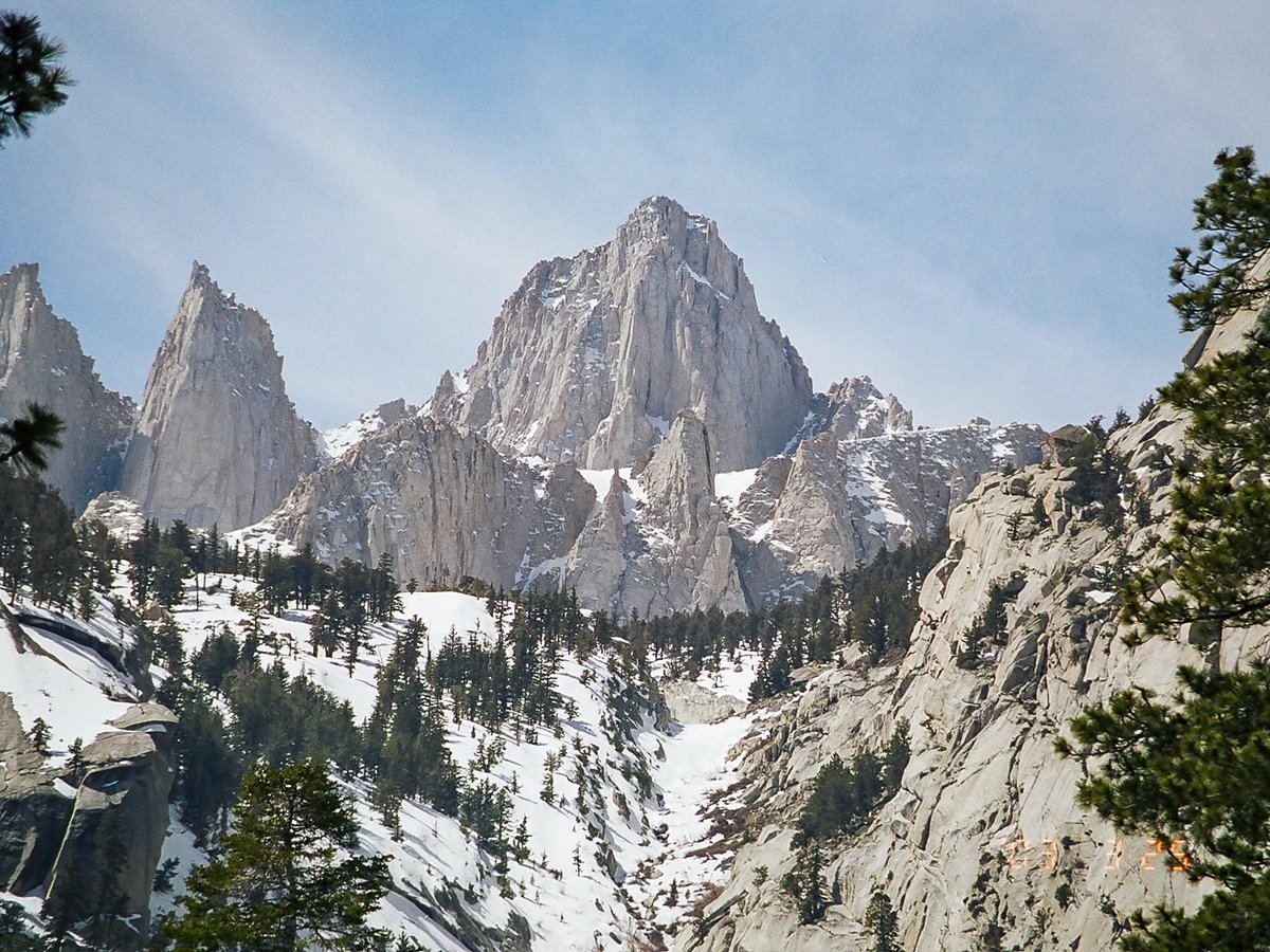
Photo: Geographer (talk · contribs) via Wikimedia Commons, CC BY 1.0. Cropped and resized for display.
Landmark facts
| Location | Lone Pine, United States |
|---|---|
| Type | Natural Wonder |
| Elevation | Elevation: 4421 m |
| Coordinates | 36.5786° N, 118.2920° W |
Every fact above is taken from the sources listed below; anything no source states is left blank rather than guessed.
What Mount Whitney is known for
Mount Whitney (Paiute: Tumanguya) is a mountain in California's Sierra Nevada range, and is the highest point in the contiguous United States, with an elevat.
About Mount Whitney
Mount Whitney (Paiute: Tumanguya) is a mountain in California's Sierra Nevada range, and is the highest point in the contiguous United States, with an elevation of 14,505 feet (4,421 m). It is located in East–Central California along the border of Inyo and Tulare counties. The mountain's west slope is in Sequoia National Park and the summit is the southern terminus of the John Muir Trail, which runs 211.9 mi (341.0 km) from Happy Isles in Yosemite Valley.
History
Exploration history Mount Whitney as seen from Mount Langley In July 1864, the members of the California Geological Survey named the peak, the contiguous United States' highest summit, after Josiah Whitney, the state geologist of California and sponsor of the survey. 1 During the same expedition, geologist Clarence King attempted to climb Whitney from its west side, but stopped just short. In 1871, King returned to climb what he believed to be Whitney, but having taken a different approach, he actually summited nearby Mount Langley.
How to get there
| Nearest town | Lone Pine |
|---|---|
| Nearest airport | Fresno Yosemite International Airport (FAT) |
| Distance from the airport | 80.2 miles (straight line) |
Nearest major airport by straight-line distance from the landmark’s coordinates; road distance will be longer.
Airports near this landmark
The airports a visitor would actually fly into, nearest first — each link opens its profile on our sister site AirportProfiles.
- Fresno Yosemite International Airport (FAT) · Fresno, United States · 80.2 miles away
Landmarks nearby
The closest landmarks in this library, by straight-line distance.


More landmarks in United States

More natural wonders

Frequently asked questions
What is Mount Whitney?
Mount Whitney (Paiute: Tumanguya) is a mountain in California's Sierra Nevada range, and is the highest point in the contiguous United States, with an elevat.
Where is Mount Whitney located?
Mount Whitney is in Lone Pine, United States. Its coordinates are 36.5786° N, 118.2920° W.
How do I get to Mount Whitney?
The nearest town is Lone Pine, and the nearest airport is Fresno Yosemite International Airport (FAT), about 80.2 miles away (straight line).
What is the history of Mount Whitney?
Exploration history Mount Whitney as seen from Mount Langley In July 1864, the members of the California Geological Survey named the peak, the contiguous United States' highest summit, after Josiah Whitney, the state geologist of California and sponsor of the survey. 1 During the same expedition, geologist Clarence King attempted to climb Whitney from its west side, but stopped just short.
Sources
- https://en.wikipedia.org/wiki/Mount_Whitney — Wikipedia article — overview, history and core facts (CC BY-SA).
- https://www.wikidata.org/wiki/Q235539 — Wikidata — built year, architect, height/size, visitors, official website (CC0).
- https://github.com/jbrooksuk/JSON-Airports — Nearest major airport computed from landmark and airport coordinates (haversine); airport list: jbrooksuk/JSON-Airports.
Page last updated 13 November 2026.