
Natural Wonder · Georgetown, Guyana
Kaieteur Falls
Kaieteur Falls is one of the most powerful single-drop waterfalls in the world.
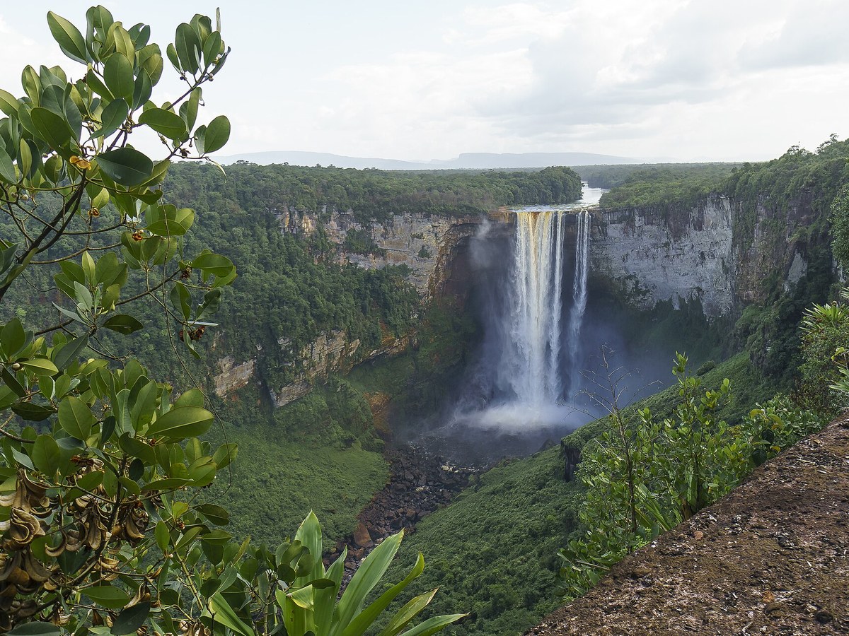
Photo: Dan Sloan via Wikimedia Commons, CC BY-SA 2.0. Cropped and resized for display.
Landmark facts
| Location | Georgetown, Guyana |
|---|---|
| Type | Natural Wonder |
| Height | Height: 226 m |
| Coordinates | 5.1750° N, 59.4805° W |
Every fact above is taken from the sources listed below; anything no source states is left blank rather than guessed.
What Kaieteur Falls is known for
Kaieteur Falls is one of the most powerful single-drop waterfalls in the world.
About Kaieteur Falls
Kaieteur Falls is one of the most powerful single-drop waterfalls in the world. It is located on the Potaro River in Kaieteur National Park, central Essequibo Territory, Guyana. It is 226 metres high when measured from its plunge over a sandstone and conglomerate cliff to the first break. It then flows over a series of steep cascades that, when included in the measurements, bring the total height to 251 metres.
History
Long known about by Indigenous nations in the area, the falls were noticed by Europeans in 1870 by a party led by Charles Barrington Brown, a British geologist appointed as a government surveyor to the colony of British Guiana. Brown and his partner James Sawkins had arrived in Georgetown in 1867; they worked both together and independently, which resulted in Brown discovering the falls alone. He did not have time to investigate Kaieteur Falls closely, so he returned one year later to make comprehensive measurements. Brown's book Canoe and Camp life in British Guiana was published in 1876.
How to get there
| Nearest town | Georgetown |
|---|---|
| Nearest airport | Santa Elena de Uairen Airport (SNV) |
| Distance from the airport | 120.6 miles (straight line) |
Nearest major airport by straight-line distance from the landmark’s coordinates; road distance will be longer.
Airports near this landmark
The airports a visitor would actually fly into, nearest first — each link opens its profile on our sister site AirportProfiles.
- Cheddi Jagan International Airport (GEO) · Georgetown, Guyana · 124.4 miles away
Landmarks nearby
The closest landmarks in this library, by straight-line distance.

More landmarks in Guyana
More natural wonders

Frequently asked questions
What is Kaieteur Falls?
Kaieteur Falls is one of the most powerful single-drop waterfalls in the world.
Where is Kaieteur Falls located?
Kaieteur Falls is in Georgetown, Guyana. Its coordinates are 5.1750° N, 59.4805° W.
How do I get to Kaieteur Falls?
The nearest town is Georgetown, and the nearest airport is Santa Elena de Uairen Airport (SNV), about 120.6 miles away (straight line).
What is the history of Kaieteur Falls?
Long known about by Indigenous nations in the area, the falls were noticed by Europeans in 1870 by a party led by Charles Barrington Brown, a British geologist appointed as a government surveyor to the colony of British Guiana. Brown and his partner James Sawkins had arrived in Georgetown in 1867; they worked both together and independently, which resulted in Brown discovering the falls alone.
Sources
- https://en.wikipedia.org/wiki/Kaieteur_Falls — Wikipedia article — overview, history and core facts (CC BY-SA).
- https://www.wikidata.org/wiki/Q38120 — Wikidata — built year, architect, height/size, visitors, official website (CC0).
- https://github.com/jbrooksuk/JSON-Airports — Nearest major airport computed from landmark and airport coordinates (haversine); airport list: jbrooksuk/JSON-Airports.
Page last updated 13 November 2026.