
Bridge · Lucerne, Switzerland
Chapel Bridge
The Kapellbrücke (from German 'Chapel Bridge') is a covered wooden footbridge spanning the river Reuss diagonally in the city of Lucerne in central Switzerland. Built 1360.
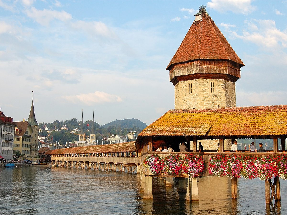
Photo: Simon Koopmann via Wikimedia Commons, CC BY-SA 2.5. Cropped and resized for display.
Landmark facts
| Location | Lucerne, Switzerland |
|---|---|
| Type | Bridge |
| Built | 1360 |
| Length | Length: 204.7 m |
| Coordinates | 47.0517° N, 8.3075° E |
Every fact above is taken from the sources listed below; anything no source states is left blank rather than guessed.
What Chapel Bridge is known for
The Kapellbrücke (from German 'Chapel Bridge') is a covered wooden footbridge spanning the river Reuss diagonally in the city of Lucerne in central Switzerland.
About Chapel Bridge
The Kapellbrücke (from German 'Chapel Bridge') is a covered wooden footbridge spanning the river Reuss diagonally in the city of Lucerne in central Switzerland. Named after the nearby St. Peter's Chapel, the bridge is unique in containing a number of interior paintings dating back to the 17th century, although many of them were destroyed along with a larger part of the centuries-old bridge in a 1993 fire.
History
Part of the bridge complex is the octagonal 34.5 m (113 ft) tall (from ground) "Wasserturm", which translates to "water tower," in the sense of "tower standing in the water." The tower pre-dated the bridge by about 30 years. Over the centuries, the tower has been used as a prison, torture chamber, and later a municipal archive as well as a local treasury. Today, the tower is closed to the public, although it houses a local artillery association and a tourist gift shop.
How to get there
| Nearest town | Lucerne |
|---|---|
| Nearest airport | Bern Belp Airport (BRN) |
| Distance from the airport | 39.1 miles (straight line) |
Nearest major airport by straight-line distance from the landmark’s coordinates; road distance will be longer.
Airports near this landmark
The airports a visitor would actually fly into, nearest first — each link opens its profile on our sister site AirportProfiles.
- Zürich Airport (ZRH) · Zurich, Switzerland · 30.3 miles away
- EuroAirport Basel–Mulhouse–Freiburg (BSL) · Bâle / Mulhouse, France · 52.9 miles away
- Bodensee Airport Friedrichshafen (FDH) · Friedrichshafen, Germany · 70.8 miles away
Landmarks nearby
The closest landmarks in this library, by straight-line distance.



More landmarks in Switzerland
More bridges

Frequently asked questions
What is Chapel Bridge?
The Kapellbrücke (from German 'Chapel Bridge') is a covered wooden footbridge spanning the river Reuss diagonally in the city of Lucerne in central Switzerland.
Where is Chapel Bridge located?
Chapel Bridge is in Lucerne, Switzerland. Its coordinates are 47.0517° N, 8.3075° E.
How do I get to Chapel Bridge?
The nearest town is Lucerne, and the nearest airport is Bern Belp Airport (BRN), about 39.1 miles away (straight line).
When was Chapel Bridge built?
Chapel Bridge was built 1360.
Sources
- https://en.wikipedia.org/wiki/Kapellbrücke — Wikipedia article — overview, history and core facts (CC BY-SA).
- https://www.wikidata.org/wiki/Q25225 — Wikidata — built year, architect, height/size, visitors, official website (CC0).
- https://github.com/jbrooksuk/JSON-Airports — Nearest major airport computed from landmark and airport coordinates (haversine); airport list: jbrooksuk/JSON-Airports.
Page last updated 13 November 2026.