
Historic Site · Bagan, Myanmar
Bagan Temples
Bagan is a medieval city and a UNESCO World Heritage Site in the Mandalay Region of Myanmar. Built 200.
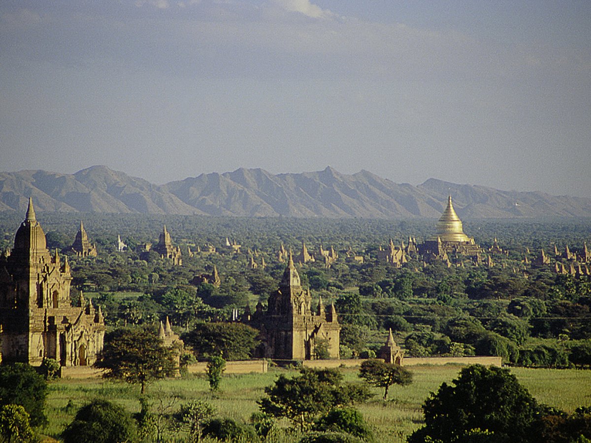
Photo: Corto Maltese 1999 via Wikimedia Commons, CC BY 2.0. Cropped and resized for display.
Landmark facts
| Location | Bagan, Myanmar |
|---|---|
| Type | Historic Site |
| Built | 200 |
| Area | Area: 181.468 km² |
| Coordinates | 21.1725° N, 94.8600° E |
Every fact above is taken from the sources listed below; anything no source states is left blank rather than guessed.
What Bagan Temples is known for
Bagan is a medieval city and a UNESCO World Heritage Site in the Mandalay Region of Myanmar.
About Bagan Temples
Bagan is a medieval city and a UNESCO World Heritage Site in the Mandalay Region of Myanmar. From the 9th to 13th centuries, the city was the capital of the Pagan Kingdom, the first kingdom that unified the regions that would later constitute Myanmar. During the kingdom's height between the 11th and 13th centuries, more than 10,000 Buddhist temples, pagodas and monasteries were constructed in the Bagan plains alone, of which the remains of over 2,300 temples and pagodas survive.
History
9th to 13th centuries According to the Burmese chronicles, Bagan was founded in the second century CE, and fortified in 849 by King Pyinbya, 34th successor of the founder of early Bagan. Western scholarship however holds that Bagan was founded in the mid-to-late 9th century by the Mranma (Burmans), who had recently entered the Irrawaddy valley from the Nanzhao Kingdom. It was among several competing Pyu city-states until the late 10th century when the Burman settlement grew in authority and grandeur.
How to get there
| Nearest town | Bagan |
|---|---|
| Nearest airport | Mandalay International Airport (MDL) |
| Distance from the airport | 95.0 miles (straight line) |
Nearest major airport by straight-line distance from the landmark’s coordinates; road distance will be longer.
Airports near this landmark
The airports a visitor would actually fly into, nearest first — each link opens its profile on our sister site AirportProfiles.
- Mandalay International Airport (MDL) · Mandalay, Myanmar · 80.7 miles away
- Nay Pyi Taw International Airport (NYT) · Naypyitaw, Myanmar · 137.8 miles away
Landmarks nearby
The closest landmarks in this library, by straight-line distance.
More landmarks in Myanmar
More historic sites





Frequently asked questions
What is Bagan Temples?
Bagan is a medieval city and a UNESCO World Heritage Site in the Mandalay Region of Myanmar.
Where is Bagan Temples located?
Bagan Temples is in Bagan, Myanmar. Its coordinates are 21.1725° N, 94.8600° E.
How do I get to Bagan Temples?
The nearest town is Bagan, and the nearest airport is Mandalay International Airport (MDL), about 95.0 miles away (straight line).
When was Bagan Temples built?
Bagan Temples was built 200.
Sources
- https://en.wikipedia.org/wiki/Bagan — Wikipedia article — overview, history and core facts (CC BY-SA).
- https://www.wikidata.org/wiki/Q29317 — Wikidata — built year, architect, height/size, visitors, official website (CC0).
- https://github.com/jbrooksuk/JSON-Airports — Nearest major airport computed from landmark and airport coordinates (haversine); airport list: jbrooksuk/JSON-Airports.
Page last updated 13 November 2026.