
Natural Wonder · Hong Kong, China
Victoria Peak
Victoria Peak (Chinese: 太平山; Jyutping: taai3 ping4 saan1) is a hill on the western half of Hong Kong Island.
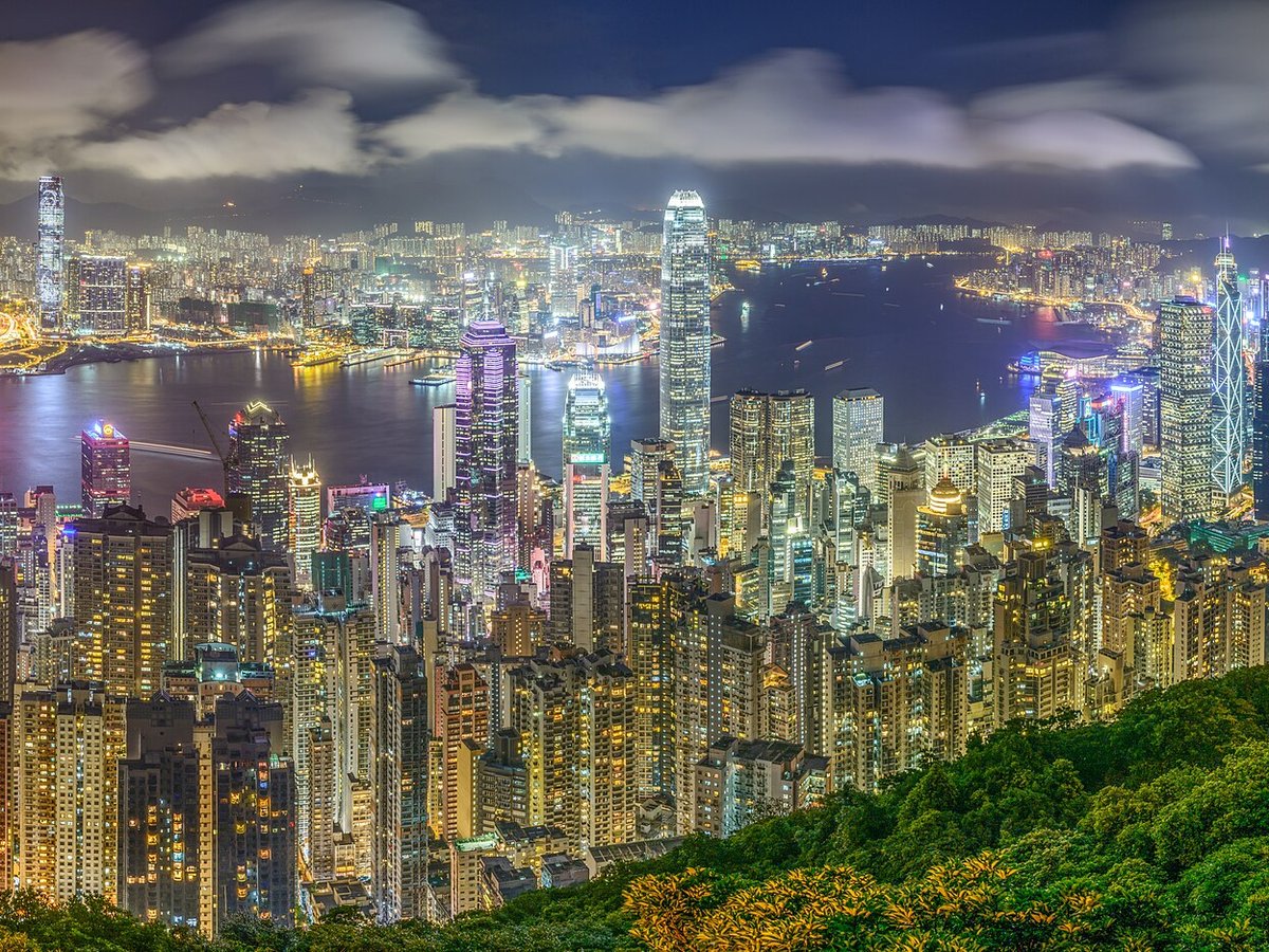
Photo: Haydn Hsin via Wikimedia Commons, CC BY-SA 3.0. Cropped and resized for display.
Landmark facts
| Location | Hong Kong, China |
|---|---|
| Type | Natural Wonder |
| Elevation | Elevation: 552 m |
| Coordinates | 22.2756° N, 114.1439° E |
Every fact above is taken from the sources listed below; anything no source states is left blank rather than guessed.
What Victoria Peak is known for
Victoria Peak (Chinese: 太平山; Jyutping: taai3 ping4 saan1) is a hill on the western half of Hong Kong Island.
About Victoria Peak
Victoria Peak (Chinese: 太平山; Jyutping: taai3 ping4 saan1) is a hill on the western half of Hong Kong Island. It is also known as the Mount Austin, and locally as The Peak only generally. With an elevation of 552 metres (1,811 ft), it is the tallest hill on Hong Kong Island, and the 29th tallest in the territory of Hong Kong.
History
As early as the 19th century, the Peak attracted prominent European residents because of its panoramic view over the city and its temperate climate compared to the sub-tropical climate in the rest of Hong Kong. The sixth Governor of Hong Kong, Sir Richard MacDonnell had a summer residence built on the Peak circa 1868. Those that built houses named them whimsically, such as The Eyrie, and the Austin Arms.
How to get there
| Nearest town | Hong Kong |
|---|---|
| Nearest airport | Chek Lap Kok International Airport (HKG) |
| Distance from the airport | 13.5 miles (straight line) |
Nearest major airport by straight-line distance from the landmark’s coordinates; road distance will be longer.
Airports near this landmark
The airports a visitor would actually fly into, nearest first — each link opens its profile on our sister site AirportProfiles.
- Hong Kong International Airport (HKG) · Hong Kong, Hong Kong · 14.9 miles away
- Shenzhen Bao'an International Airport (SZX) · Shenzhen, China · 33.2 miles away
- Macau International Airport (MFM) · Nossa Senhora do Carmo, Macau · 36.4 miles away
Landmarks nearby
The closest landmarks in this library, by straight-line distance.
More landmarks in China
More natural wonders

Frequently asked questions
What is Victoria Peak?
Victoria Peak (Chinese: 太平山; Jyutping: taai3 ping4 saan1) is a hill on the western half of Hong Kong Island.
Where is Victoria Peak located?
Victoria Peak is in Hong Kong, China. Its coordinates are 22.2756° N, 114.1439° E.
How do I get to Victoria Peak?
The nearest town is Hong Kong, and the nearest airport is Chek Lap Kok International Airport (HKG), about 13.5 miles away (straight line).
What is the history of Victoria Peak?
As early as the 19th century, the Peak attracted prominent European residents because of its panoramic view over the city and its temperate climate compared to the sub-tropical climate in the rest of Hong Kong. The sixth Governor of Hong Kong, Sir Richard MacDonnell had a summer residence built on the Peak circa 1868.
Sources
- https://en.wikipedia.org/wiki/Victoria_Peak — Wikipedia article — overview, history and core facts (CC BY-SA).
- https://www.wikidata.org/wiki/Q17541 — Wikidata — built year, architect, height/size, visitors, official website (CC0).
- https://github.com/jbrooksuk/JSON-Airports — Nearest major airport computed from landmark and airport coordinates (haversine); airport list: jbrooksuk/JSON-Airports.
Page last updated 13 November 2026.