
Natural Wonder · Kota Kinabalu, Malaysia
Mount Kinabalu
Mount Kinabalu (Dusun: Gayo Ngaran or Nulu Nabalu, Malay: Gunung Kinabalu) is the highest mountain in Malaysia and Maritime Southeast Asia, located on the island of Borneo in Sabah.
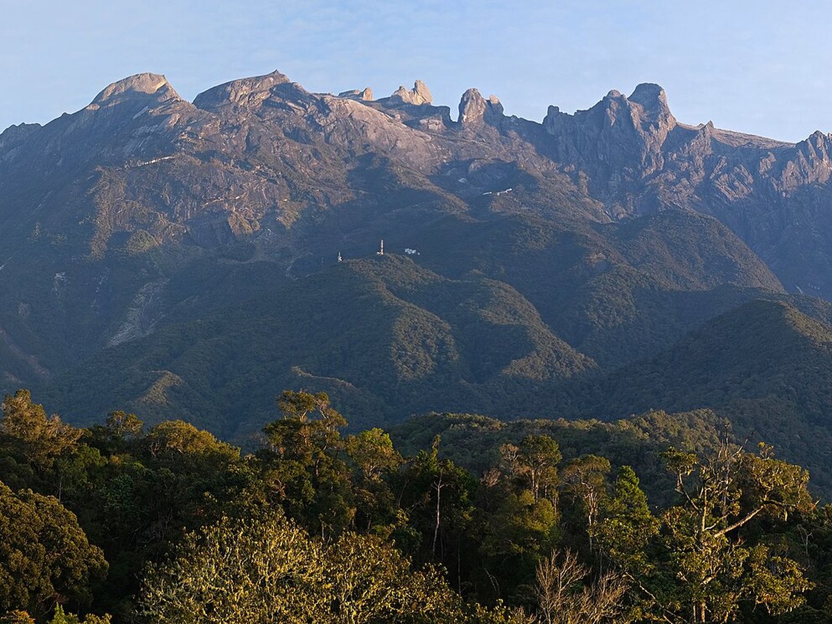
Photo: kallerna via Wikimedia Commons, CC BY-SA 4.0. Cropped and resized for display.
Landmark facts
| Location | Kota Kinabalu, Malaysia |
|---|---|
| Type | Natural Wonder |
| Elevation | Elevation: 4095 m |
| Coordinates | 6.0750° N, 116.5586° E |
Every fact above is taken from the sources listed below; anything no source states is left blank rather than guessed.
What Mount Kinabalu is known for
Mount Kinabalu (Dusun: Gayo Ngaran or Nulu Nabalu, Malay: Gunung Kinabalu) is the highest mountain in Malaysia and Maritime Southeast Asia, located on the island of Borneo in Sabah.
About Mount Kinabalu
Mount Kinabalu (Dusun: Gayo Ngaran or Nulu Nabalu, Malay: Gunung Kinabalu) is the highest mountain in Malaysia and Maritime Southeast Asia, located on the island of Borneo in Sabah. With a height of 4,095 metres (13,435 ft), it is the third-highest peak of an island on Earth, the 28th-highest peak in Southeast Asia, and 20th-most-prominent mountain in the world. The mountain is located in Ranau district, West Coast Division of Sabah, Malaysia.
History
British colonial administrator Hugh Low made the first recorded ascent of Mount Kinabalu's summit plateau in March 1851 with local Dusun guide Lemaing of Kampung Kiau. Low did not scale the mountain's highest peak, however, considering it "inaccessible to any but winged animals". In April and July 1858, Low was accompanied on two further ascents by Spenser St.
How to get there
| Nearest town | Kota Kinabalu |
|---|---|
| Nearest airport | Kota Kinabalu International Airport (BKI) |
| Distance from the airport | 36.4 miles (straight line) |
Nearest major airport by straight-line distance from the landmark’s coordinates; road distance will be longer.
Airports near this landmark
The airports a visitor would actually fly into, nearest first — each link opens its profile on our sister site AirportProfiles.
- Kota Kinabalu International Airport (BKI) · Kota Kinabalu, Malaysia · 36.3 miles away
- Brunei International Airport (BWN) · Bandar Seri Begawan, Brunei · 136.7 miles away
Landmarks nearby
The closest landmarks in this library, by straight-line distance.

More landmarks in Malaysia
More natural wonders


Frequently asked questions
What is Mount Kinabalu?
Mount Kinabalu (Dusun: Gayo Ngaran or Nulu Nabalu, Malay: Gunung Kinabalu) is the highest mountain in Malaysia and Maritime Southeast Asia, located on the island of Borneo in Sabah.
Where is Mount Kinabalu located?
Mount Kinabalu is in Kota Kinabalu, Malaysia. Its coordinates are 6.0750° N, 116.5586° E.
How do I get to Mount Kinabalu?
The nearest town is Kota Kinabalu, and the nearest airport is Kota Kinabalu International Airport (BKI), about 36.4 miles away (straight line).
What is the history of Mount Kinabalu?
British colonial administrator Hugh Low made the first recorded ascent of Mount Kinabalu's summit plateau in March 1851 with local Dusun guide Lemaing of Kampung Kiau. Low did not scale the mountain's highest peak, however, considering it "inaccessible to any but winged animals".
Sources
- https://en.wikipedia.org/wiki/Mount_Kinabalu — Wikipedia article — overview, history and core facts (CC BY-SA).
- https://www.wikidata.org/wiki/Q60967 — Wikidata — built year, architect, height/size, visitors, official website (CC0).
- https://github.com/jbrooksuk/JSON-Airports — Nearest major airport computed from landmark and airport coordinates (haversine); airport list: jbrooksuk/JSON-Airports.
Page last updated 13 November 2026.