
Monument · Tehran, Iran
Azadi Tower
The Azadi Tower (Persian: برج آزادی, romanized: Borj-e Āzādi, lit. Built 1971.
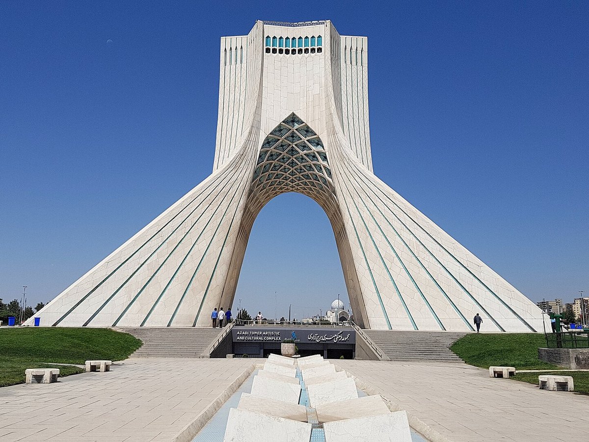
Photo: Blondinrikard Fröberg from Göteborg, Sweden via Wikimedia Commons, CC BY 2.0. Cropped and resized for display.
Landmark facts
| Location | Tehran, Iran |
|---|---|
| Type | Monument |
| Built | 1971 |
| Architect | Hossein Amanat |
| Height | Height: 45 m |
| Coordinates | 35.6994° N, 51.3378° E |
Every fact above is taken from the sources listed below; anything no source states is left blank rather than guessed.
What Azadi Tower is known for
The Azadi Tower (Persian: برج آزادی, romanized: Borj-e Āzādi, lit.
About Azadi Tower
The Azadi Tower (Persian: برج آزادی, romanized: Borj-e Āzādi, lit. 'Freedom Tower'), also known by its former name, the Shahyad Tower (Persian: برج شهیاد, romanized: Borj-e Šahyād, lit. 'Shah's Memorial Tower'), is a monument at Azadi Square in Tehran, Iran.
History
The first name associated with this monument was Darvāze-ye Kuroš ("Gate of Cyrus"), and at the time of the Centenary Celebrations, Asadollah Alam, who chaired the Council of Celebrations, referred to the monument as Darvāze-ye Šāhanšāhi ("Imperial Gate"). The monument's ultimate official name was decided before the announcement of the competition for the monument's design in September 1966. Bahram Farahvashi, a scholar and professor of ancient Iranian languages who worked with the Council of Celebrations, came up with the officially designated name of the structure, Šahyād Āryāmehr.
How to get there
| Nearest town | Tehran |
|---|---|
| Nearest airport | Mehrabad International Airport (THR) |
| Distance from the airport | 1.0 miles (straight line) |
Nearest major airport by straight-line distance from the landmark’s coordinates; road distance will be longer.
Airports near this landmark
The airports a visitor would actually fly into, nearest first — each link opens its profile on our sister site AirportProfiles.
- Mehrabad International Airport (THR) · Tehran, Iran · 1.5 miles away
- Imam Khomeini International Airport (IKA) · Tehran, Iran · 22.2 miles away
- Payam International Airport (PYK) · Karaj, Iran · 29.1 miles away
Landmarks nearby
The closest landmarks in this library, by straight-line distance.
More landmarks in Iran
More monuments


Frequently asked questions
What is Azadi Tower?
The Azadi Tower (Persian: برج آزادی, romanized: Borj-e Āzādi, lit.
Where is Azadi Tower located?
Azadi Tower is in Tehran, Iran. Its coordinates are 35.6994° N, 51.3378° E.
How do I get to Azadi Tower?
The nearest town is Tehran, and the nearest airport is Mehrabad International Airport (THR), about 1.0 miles away (straight line).
When was Azadi Tower built?
Azadi Tower was built 1971.
Sources
- https://en.wikipedia.org/wiki/Azadi_Tower — Wikipedia article — overview, history and core facts (CC BY-SA).
- https://www.wikidata.org/wiki/Q1140026 — Wikidata — built year, architect, height/size, visitors, official website (CC0).
- https://github.com/jbrooksuk/JSON-Airports — Nearest major airport computed from landmark and airport coordinates (haversine); airport list: jbrooksuk/JSON-Airports.
Page last updated 13 November 2026.